Abstract
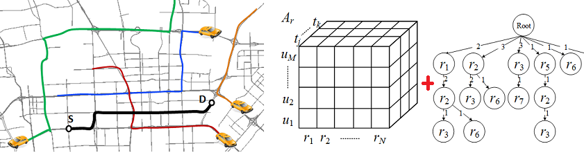
In this paper, we propose a citywide and real-time model for estimating the travel time of any path (represented as a sequence of connected road segments) in real time in a city, based on the GPS trajectories of vehicles received in current time slots and over a period of history as well as map data sources. Though this is a strategically important task in many traffic monitoring and routing systems, the problem has not been well solved yet given the following three challenges. The first is the data sparsity problem, i.e., many road segments may not be traveled by any GPS-equipped vehicles in present time slot. In most cases, we cannot find a trajectory exactly traversing a query path either. Second, for the fragment of a path with trajectories, they are multiple ways of using (or combining) the trajectories to estimate the corresponding travel time. Finding an optimal combination is a challenging problem, subject to a tradeoff between the length of a path and the number of trajectories traversing the path (i.e., support). Third, we need to instantly answer users’ queries which may occur in any part of a given city. This calls for an efficient, scalable and effective solution that can enable a citywide and real-time travel time estimation. To address these challenges, we model different drivers’ travel times on different road segments in different time slots with a three dimension tensor. Combined with geospatial, temporal and historical contexts learned from trajectories and map data, we fill in the tensor’s missing values through a context- aware tensor decomposition approach. We then devise and prove an object function to model the aforementioned tradeoff, with which we find the most optimal concatenation of trajectories for an estimate through a dynamic programming solution. In addition, we propose using frequent trajectory patterns (mined from historical trajectories) to scale down the candidates of concatenation and a suffix-tree-based index to manage the trajectories received in the present time slot. We evaluate our method based on extensive experiments, using GPS trajectories generated by more than 32,000 taxis over a period of two months. The results demonstrate the effectiveness, efficiency and scalability of our method beyond baseline approaches.
(Data and Codes) (PPT)